
|
Storms are possible for North Texas Residents this afternoon & evening. The Storm Prediction Center (SPC) has put a large chunk of North Texas under an Enhanced Risk for severe weather for tonight. An enhanced risk is level 3 of 5 on the SPC's scale. The main threats that are expected tomorrow will be damaging wind gusts up to 80 MPH, large to very large hail, and a few tornadoes will be possible.  According to our Severe Weather Center & Storm Prediction Center, an Enhanced Risk of severe weather exists in nearly all of the NTXWC coverage area. This area has the greatest chance for large to very large hail, damaging winds and maybe a few tornadoes. Up to baseball sized hail will be possible.
Here is NTXWC's Probabilities for today's storms: (This is for anywhere in the severe weather potential region, not just North Texas) Probability of 1+ Tornado: 70% Probability of 2+ Tornadoes: 30% Probability of 3+ Tornadoes: 10% Probability of 3+ Large Hail Reports: 95% Probability of 7+ Large Hail Reports: 50% Probability of 3+ Damaging Wind Reports: 80% Probability of 7+ Damaging Wind Reports: 35% Probability of 1+ Damaging Wind 70+ MPH Occurrence: 60% TIMING: Storms will fire up between Abilene and I-35w between 3-6pm. These storms will reach the DFW metroplex by as early as 6pm, and will likely exit or weaken by 9pm. Make sure to have a safety plan in place today in case you are under a tornado warning. Be prepared for rapidly changing weather conditions. Cover your vehicles to keep hail damage to a minimum. Bring in trash and recycling bins, plants, and any loose furniture inside to prevent those items from being damaged by damaging winds. Our full, "How to Prepare for Severe Weather" guide can be seen by clicking the blue text. Do you OWN A BUSINESS? Want to advertise to 1,000,000+ North Texas Residents per month? Contact NTXWC on Facebook (by messages) for more information! Subscribe to our YouTube Channel (Click me) Follow us on Facebook (Click me) Writer: Max To start off the weekend, the northwesterly flow behind the cold front will quickly shift to a more light southerly regime Saturday morning, with winds increasing through the afternoon. And with increasing winds and dry air, there lies an increased fire weather risk. Now you may be asking: "But don't southerly winds carry moisture north? Why is the air still dry?" This is a very frequently asked question, and the answer is simply because moisture takes time to transport north. The winds will be gusty, but the moisture content stays on the drier side because of the time it takes to arrive. Because of this risk, the National Weather Service has us under a Red Flag Warning for Saturday... PINK = Red Flag Warning  Other than the fire risk, temperatures in the mid 80s and sunny skies can be expected, beautiful and perfect for any outdoor activities! Just make sure you are not doing anything that risks fire start. Saturday night through Sunday morning, continued southerly flow keeps our low temperatures in the upper 50s to low 60s. Throughout the day, clouds will increase and temperatures will rise into the mid 80s with warmer temperatures west of the metroplex. Southerly winds will still be kicking, so elevated Fire Danger exists for areas west of the I-35 corridor. Although the atmosphere by this time will be highly unstable, a strong cap aloft will keep storm chances out of the forecast. Sunday night through Monday morning, highs in the mid 60s are expected with partly cloudy skies and breezy southerly winds. 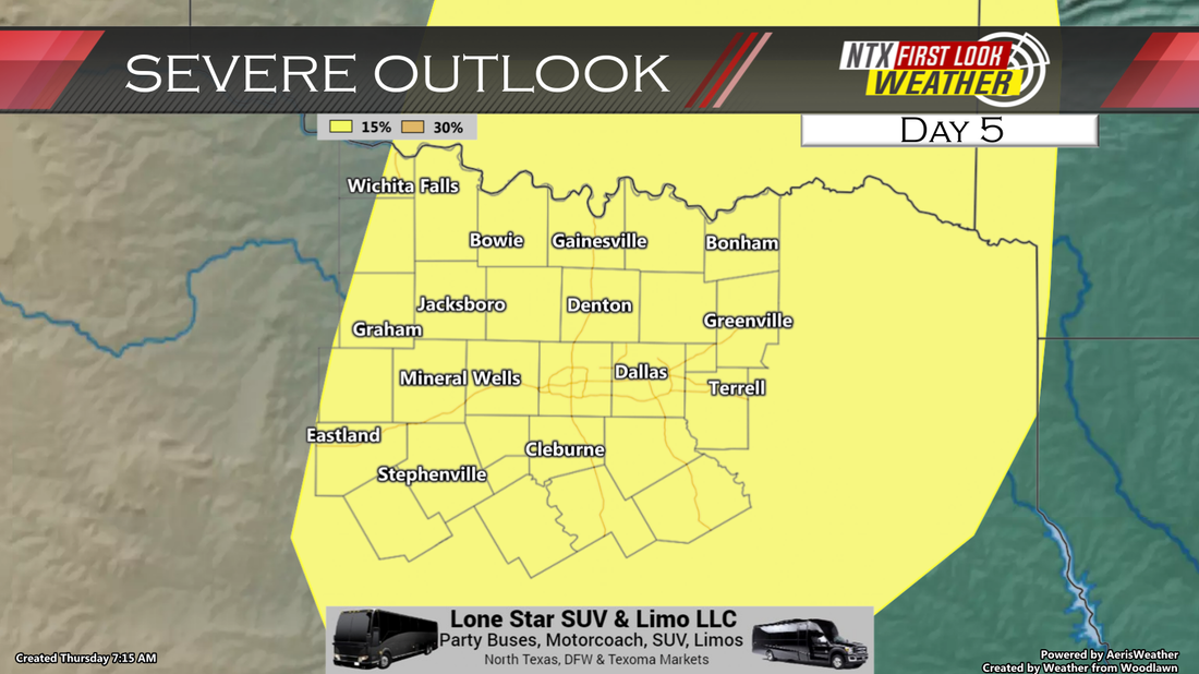 To start the work week, it'll be unseasonably warm once again as we remain in an open warm sector(essentially an area of moisture). We will still be under a strong cap for several days, with a chance for severe weather each day. Tuesday looks to hold the best chance for severe weather, with a highly unstable atmosphere. Many uncertainties to work out even at this juncture, but severe weather appears possible Mon-Wed afternoon, with all hazards likely. For the full forecast on SEVERE WEATHER potential for Monday through Wednesday, watch the forecast below: The National Weather Service has confirmed six tornadoes from last Monday's severe storms. These tornadoes happened in Collin County, Johnson County, and Ellis County. Significant wind damage was also reported in Kaufman & Van Zandt Counties.
Blue Ridge, TX, was home to one of the several tornadoes. This EF-1 tornado caused damaged in Northeastern Collin County and was on the ground from 9:32pm to 9:36pm. The tornado was on the ground for nearly 0.3 miles and was approximately 190 yards wide. Another tornado occurred in Joshua and Egan, TX. This was a strong, EF-2 tornado that caused significant damage to many homes in Johnson County. The tornado was on the ground for 10 miles and was 150 yards wide. One injury was reported from this tornado. An EF-0 tornado happened North of Alvarado. This tornado was an EF-0 that was on the ground for approximately 5 miles. The tornado was 200 yards wide. An EF-0 tornado occurred in Keene, TX, which was also in Johnson County. This tornado was on the ground for 5 miles and was 200 yards wide. An EF-0 tornado occurred North of Venus, TX, in Johnson County. This tornado was on the ground for 3 miles and was 50 yards wide. Lastly, a tornado occurred in Midlothian, TX. This tornado occurred in Ellis County. This tornado was an EF-0. The tornado was on the ground is 1.5 miles and was 30 yards wide. If you have photos and videos, make sure to message us on Facebook! Subscribe to our YouTube Channel (Click me) Follow us on Facebook (Click me) Writer: Max The National Weather Service has confirmed a 4th tornado from Monday night's severe weather across North Texas. This tornado occurred in Ellis County around 11:00pm. The tornado was confirmed in Western Midlothian, Texas. The tornado was confirmed as an EF-1 tornado with maximum sustained winds of 90 MPH. The tornado was one of three that came with a storm that rumbled through Johnson and Ellis Counties between 10:30-11:30pm. The storm moved quickly east and brought significant damage across the two counties. 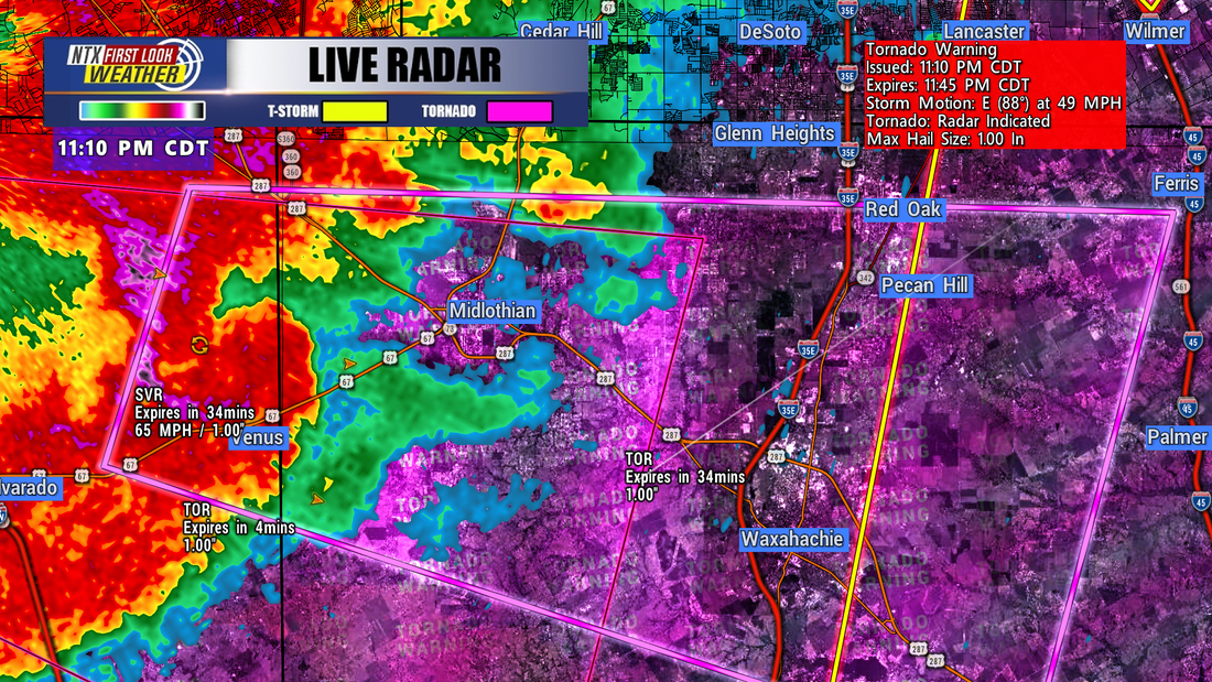 The National Weather Service has confirmed a 3rd tornado in Johnson County. The tornado occurred in Keene, TX. This tornado happened after the tornado went through Egan. The tornado in Egan lasted nearly 10 miles, while the Keene tornado was only on the ground for 1.6 miles.
The NWS confirmed that the tornado was an EF-0 in Keene, TX. It reached maximum sustained winds of 80 MPH and was 75 yards wide. |